Home

Flight planning

VFR and IFR flight planning in minutes, with official data

Build the route by tapping the map or typing the ICAO code, see the weather along the way, check weight and balance and take the flight plan to the cockpit. All on top of the official charts and aeronautical data.

Who it is for

  • Pilots who plan VFR and IFR flights
  • Flight schools and flying clubs
  • Those who fly in the simulator with a realistic flight plan
Route planned on the map of the Alfaero app with the leg table
Real app screen

Features

Tap a feature to see how it works, how to use it and the technical details.

01 / 06

VFR and IFR route on the map

Heading, distance, ETE and ETA for each leg, with SID, STAR and airways.
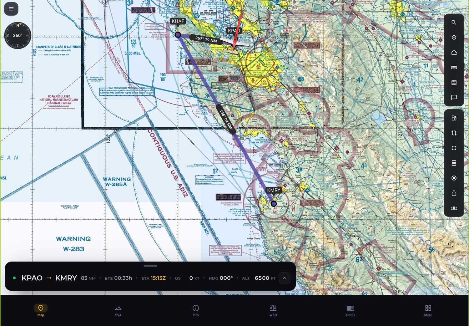
Route planned on the map of the Alfaero app with the leg table
Real app screen

How it works

You choose departure and destination and add waypoints by tapping the map or typing fixes, navaids and aerodromes. For IFR flights, the route uses SID, airways and STAR. The app calculates heading, distance, estimated time en route (ETE) and estimated time of arrival (ETA) for each leg.

How to use

  1. Tap new route and enter departure and destination.
  2. Add waypoints on the map or type fixes and airways.
  3. Choose SID and STAR when the flight is IFR.
  4. Check the leg table with heading, distance, ETE and ETA.

Technical details

Flight rules
VFR and IFR
Procedures
SID, STAR and airways
Per leg
Heading, distance, ETE and ETA
Input
Tap on the map or ICAO code
02 / 06

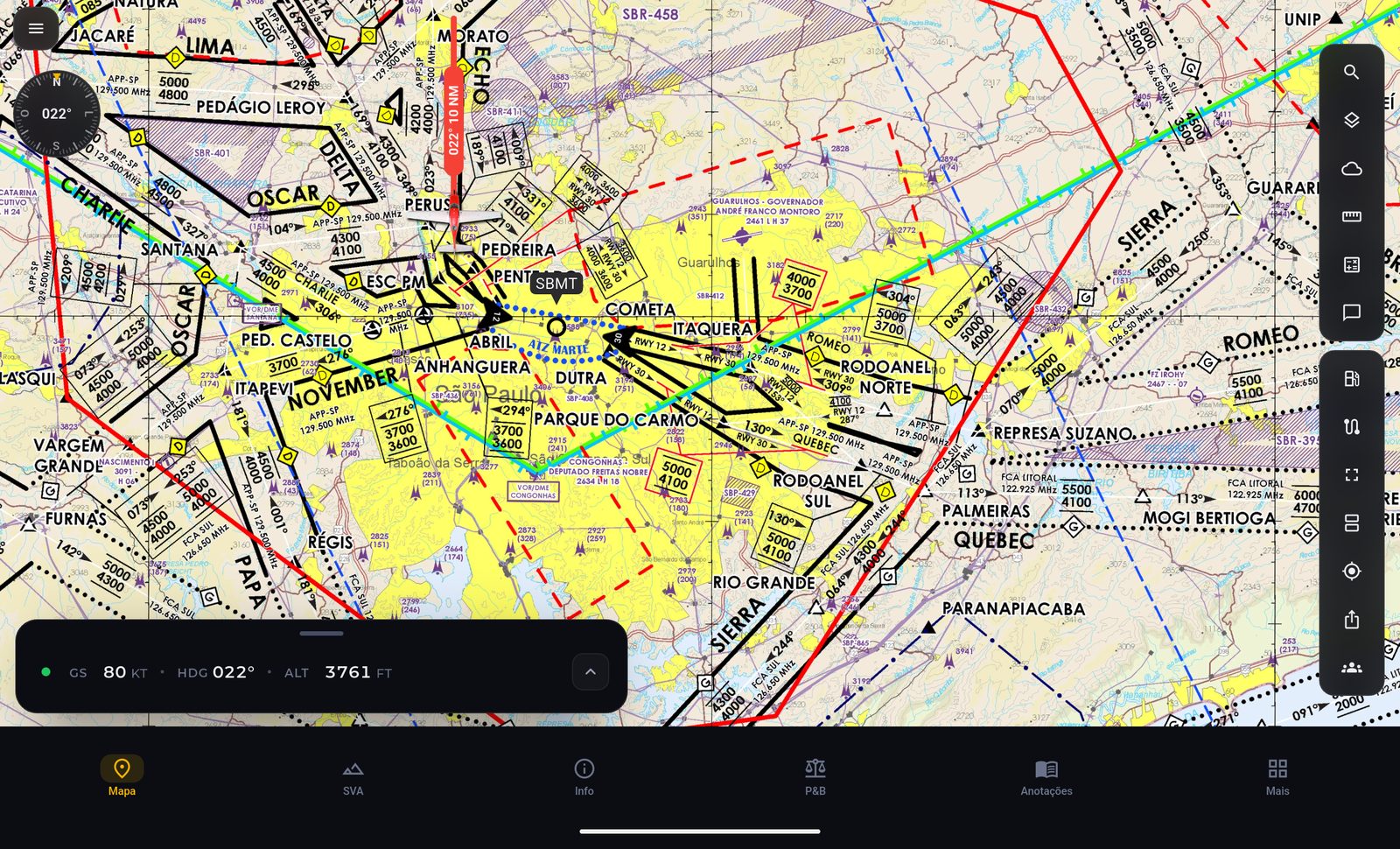
REA and REH corridors

The REA chart of terminal areas over the map, with the visual corridors.

REA chart of the Sao Paulo terminal area over the map of the Alfaero app
Real app screen

How it works

The special aircraft route (REA) and helicopter route (REH) charts of terminal areas appear over the map. You build the route following the visual corridors and see the altitude of each point.

How to use

  1. On the map, turn on the REA layer.
  2. Follow the corridors when building the route.
  3. Check the planned altitude at each point.

Technical details

Charts
REA and REH of terminal areas
Display
Over the map, in the real position
On the route
Altitude of each point
03 / 06

Route weather

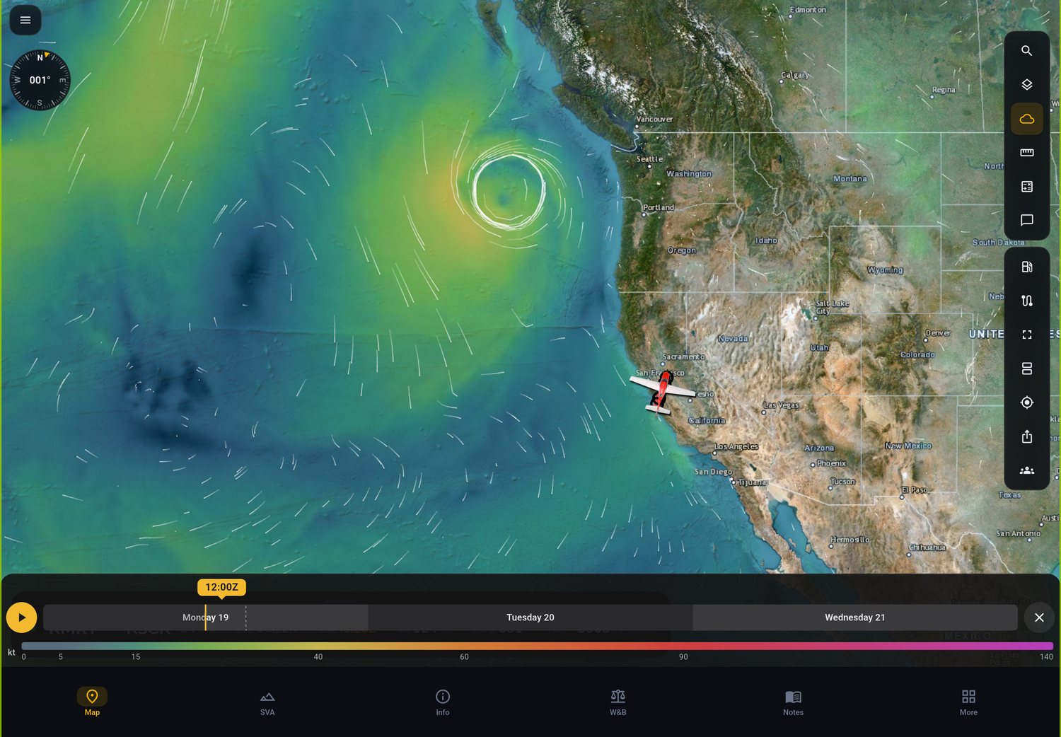
Wind, rain and SIGMET over the map, with a timeline to choose your departure time.

Wind and rain layers over the route in the Alfaero app
Real app screen

How it works

The weather layers show wind, rain and the SIGMET areas for turbulence, icing and thunderstorms along the route. The timeline moves the forecast forward so you can compare takeoff times.

How to use

  1. Open the route and turn on the weather layers.
  2. Drag the timeline to the takeoff time.
  3. Compare times and choose the best window.

Technical details

Layers
Wind, rain and SIGMET
SIGMET
Turbulence, icing and thunderstorms
Time
Forecast timeline
04 / 06

Weight and balance

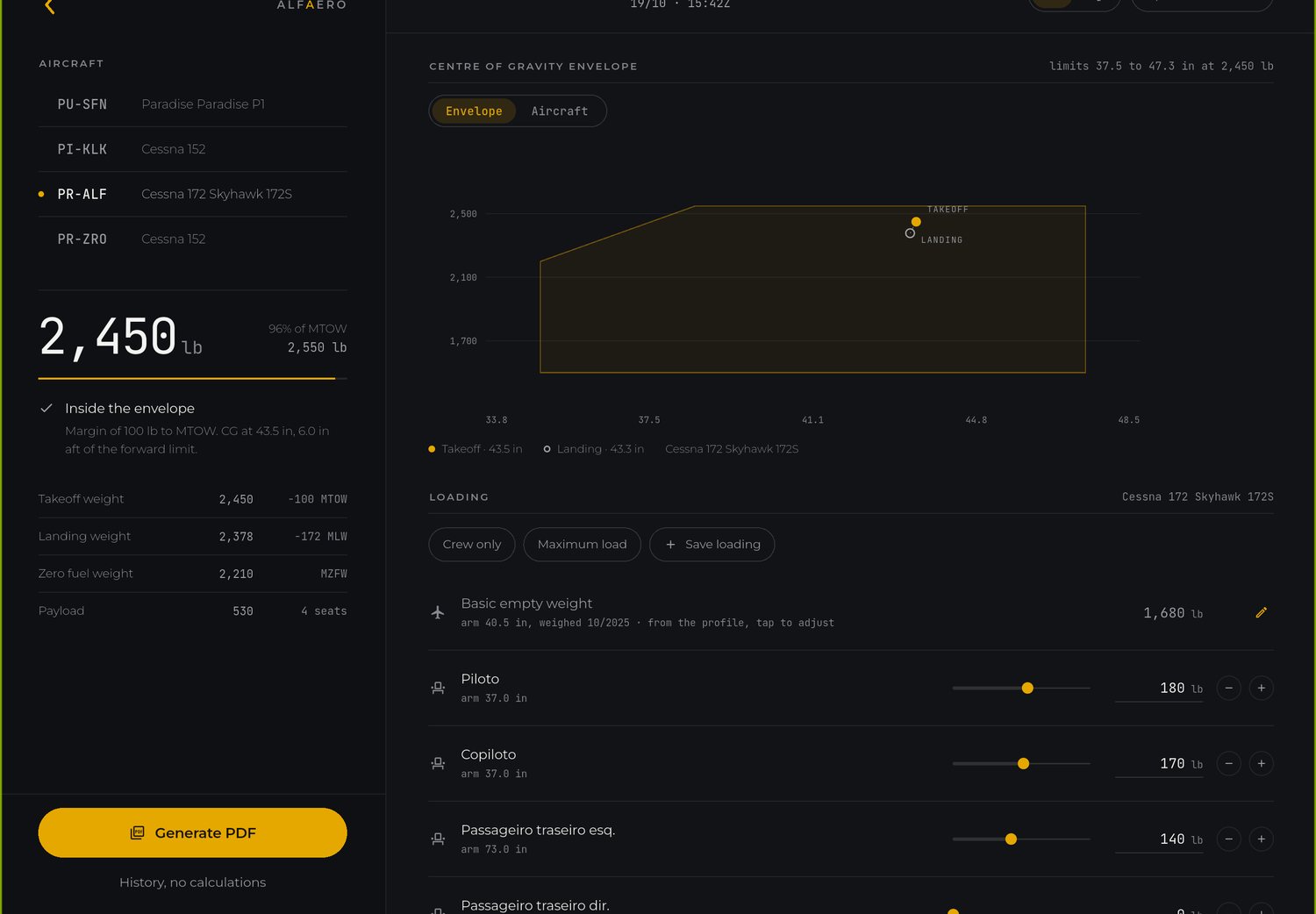
The CG inside the envelope at takeoff and landing, with a PDF to take on board.

Weight and balance in the Alfaero app with the CG inside the envelope
Real app screen

How it works

You register your aircraft profile, enter occupants, baggage and fuel, and the app shows the center of gravity (CG) in the envelope at takeoff and landing. The result comes out as a PDF.

How to use

  1. Register the aircraft with the data from the manual.
  2. Enter occupants, baggage and fuel.
  3. Check the CG in the envelope at takeoff and landing.
  4. Generate the PDF to take on board.

Technical details

Input
Aircraft profile, loads and fuel
Output
CG in the envelope at takeoff and landing
Document
PDF
05 / 06

Automatic operational flight plan

Just departure, destination and aircraft: route, runway, fuel and approach calculated.

How it works

In the Alfaero Life panel, the operational flight plan (OFP) is built from three pieces of information: departure, destination and aircraft. The route comes out with SID, airways and STAR from the navigation database, the wind comes from the forecast, the landing runway is chosen by the forecast wind at the arrival time and the approach is suggested by the minimums. The OFP comes out as 68 column text and as a PDF.

How to use

  1. Open Flight plan in the Alfaero Life panel.
  2. Enter departure, destination and aircraft.
  3. Check the route, the runways and the suggested approach.
  4. Download the PDF or copy the route.

Technical details

Input
Departure, destination and aircraft
Route
Automatic SID, airways and STAR
Landing runway
By the forecast wind at the arrival time
Output
68 column OFP and PDF
06 / 06

SimBrief integration

Send the planned route with one tap, no copy and paste.

How it works

With your SimBrief account linked, the route built in Alfaero goes to SimBrief with one tap, to generate the plan in the format you already use.

How to use

  1. Link your SimBrief account to Alfaero.
  2. Build the route in Alfaero.
  3. Send the route to SimBrief.

Technical details

Integration
SimBrief
Direction
Route from Alfaero to SimBrief
Effort
One tap

Frequently asked questions

Can I plan IFR flights with SID and STAR?

Yes. The route accepts SID, airways and STAR, and the app calculates heading, distance, ETE and ETA for each leg.

Does the app calculate weight and balance?

Yes. With the aircraft profile registered, it shows the CG in the envelope at takeoff and landing and generates a PDF.

What is the automatic OFP?

It is the operational flight plan built by the Alfaero Life panel from departure, destination and aircraft, with route, runway, approach and fuel calculated.

Try it on your next flight

Download Alfaero on your phone, tablet or Windows PC and use everything during the trial period.